When is the best time to go on Safari?
Everyone asks this question. And the honest answer is that it depends entirely on what you're looking for — because Kruger in July and Kruger in January are almost two different parks.
I've been running tours in and out of the Southern Kruger since 2009. Here's what I actually think.
If you want the easiest game viewing — come in late winter
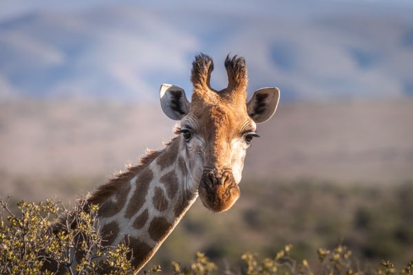
June, July and August are when most people visit, and for good reason. The bush strips back. Waterholes become the only show in town. Animals congregate, and without the thick summer foliage hiding everything, you can actually see them.
Game viewing is at its most productive. Lion, elephant, buffalo — you'll find them without working too hard. The days are clear and cool, the nights cold. It's the classic safari experience, and it delivers.
Late winter — August into September — is also worth considering if you're sensitive to malaria risk. The mosquito pressure drops significantly once the rains are gone and the bush has dried out. Combined with excellent game viewing, it's a strong choice for first-timers who want the odds stacked in their favour.
The trade-off is the landscape. The bush in winter is dry and sparse — beautiful in its own stark way, but it won't match the postcard-green images people sometimes expect.
If you want something different — come in summer
This is actually my personal preference, and I'll tell you why.
The days stretch long. Light until nearly eight in the evening, which means more hours in the park, more hours on the road, more chances for something to happen. The afternoon storms roll in fast and dramatic — lightning over the plains, the smell of rain on hot earth — and after they pass the light turns golden in a way that winter simply can't match.
The bush is thick and green and alive. Impala lambs everywhere. Birds that disappear for half the year come flooding back — bee-eaters, rollers, cuckoos, storks. If you have any interest in birding at all, summer is the season.
Yes, the game viewing is harder. Animals are spread out, water is everywhere, and the grass is tall. You have to work for your sightings. But when you find a leopard in a fever tree with a green canopy behind it, or a breeding herd of elephant against a stormy sky — those are the images that stay with you.
The rain is rarely all-day. Most afternoons, an hour of drama, and then it's done.
The honest version
First time in Kruger, want reliable sightings, not keen on heat or malaria risk → late winter, August into September.
You've been before, you love birds, you want atmosphere and long golden evenings → summer, November through January.
Either way, Kruger won't disappoint. It never does.
Ready To Go?
We run Kruger day tours from Hoedspruit year-round, and we'll tell you honestly what to expect in whatever month you're planning. No hard sell — just a good day in the bush.